Saunderstown (Rhode Island)

Saunderstown (Rhode Island)
Distrito histórico de Saunderstown
(Saunderstown Historic District)
Registro Nacional de Lugares Históricos (EE. UU.)
Distrito Histórico
Gilbert Stuart Birthplace.jpg
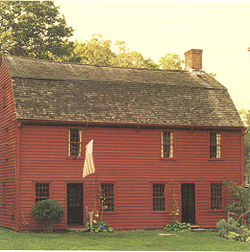
La casa natal de Gilbert Stuart, en Saunderstown.
Ubicación North Kingstown (Rhode Island)
Flag of Rhode Island.svg Rhode Island
Construido/Fundado 1856
Arquitecto Varios
Estilo Colonial Revival, Bungalow/Craftsman, Otros
Agregado al NRHP 19 de julio de 1985
Referencia NRHP 85001647[1]
MPS North Kingstown MRA
Administración Privada

Saunderstown es un pequeño pueblo de estilo colonial y distrito histórico de North Kingstown, Rhode Island. Localizado en el condado de Washington.

Saunderstown es conocida por ser el lugar de nacimiento del artista Gilbert Stuart, conocido por pintar el retrato de George Washington que sirvió para ilustrar el billete de 1 dólar. El museo y casa natal de Gilbert Stuart es la casa donde nació, la cual tiene senda natural y un molino de harina funcional. Actualmente está abierto al publico como museo.[2] Saunderstown es también la localidad donde está Casey Farm, una plantación del siglo XVIII, que actualmente es una granja familiar. La granja dispone de vegetales orgánicos, hierbas y flores para el programa comunitario de agricultura. Esta operado por Historic New England.[3]

Referencias

  1. «National Register Information System». National Register of Historic Places. National Park Service (23-1-2007).
  2. Saunderstown, Rhode Island Community Profile
  3. Historic New England, Casey Farm

Wikimedia foundation. 2010.

Игры ⚽ Поможем написать курсовую

Mira otros diccionarios:

  • Saunderstown, Rhode Island — Infobox nrhp | name =Saunderstown Historic District nrhp type = hd caption = The Gilbert Stuart Birthplace is located in Saunderstown. location= North Kingstown, Rhode Island locmapin = Rhode Island area = built =1856 architect= Multiple… …   Wikipedia

  • Rhode Island Route 1A — Route 1A is a numbered state highway in Rhode Island, running 34.4 miles in five sections.RouteRoute 1A follows U.S. 1 closely through South County. It can be separated into five sections:*The first section (8.8 miles in length) begins as US 1… …   Wikipedia

  • List of the oldest buildings in Rhode Island — See also: Oldest buildings in America This article attempts to list the oldest extant buildings surviving in the state of Rhode Island in the United States of America, including the oldest houses in Rhode Island and any other surviving structures …   Wikipedia

  • Narragansett, Rhode Island —   Town   …   Wikipedia

  • Westerly, Rhode Island —   Town   …   Wikipedia

  • Jamestown, Rhode Island — Infobox Settlement official name = Jamestown, Rhode Island settlement type = Town nickname = motto = imagesize = image caption = image mapsize = 250px map caption = Location of Jamestown in Rhode Island mapsize1 = map caption1 = subdivision type …   Wikipedia

  • Charlestown, Rhode Island —   Town   Location of Charlestown in Washington County, Rhode Island …   Wikipedia

  • Matunuck, Rhode Island — Matunuck is a village in South Kingstown, Rhode Island, United States near Charlestown, Rhode Island. The village is located on a point along the southern Atlantic coast of Rhode Island off of U.S. Route 1. The village takes its name from a… …   Wikipedia

  • Wickford, Rhode Island — Infobox nrhp | name =Wickford Historic District nrhp type = hd caption = Wickford from the air, looking east. location= North Kingstown, Rhode Island locmapin = Rhode Island area = architect= Tefft,T.A.; Sawtelle,W.C. architecture= Greek Revival …   Wikipedia

  • North Kingstown, Rhode Island —   Town   The Gilbert Stuart Birthplace in North Kingstown …   Wikipedia

Compartir el artículo y extractos

Link directo
Do a right-click on the link above
and select “Copy Link”