Stanegate

Stanegate
Mapa que muestra la ubicación del Stanegate.

El Stanegate o «camino de piedra» (Anglosajón) fue una importante calzada romana construida en la provincia de Britania. Trazada de oeste a este, esta calzada unía aproximadamente las poblaciones de Carlisle y Corbridge. Basándose en su dirección, podemos decir que el Stanegate se extendía a lo largo de la orilla del Río Eden hasta Irthington.[1] De allí, la calzada discurría a lo largo de la orilla oeste del Río Irthing hacia Gilsland, y a través del Valle del Tyne a Newcastle-upon-Tyne.

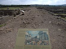
Restos del Stanegate hallados en Corbridge.

La ubicación de la Muralla de Adriano, destinada a proteger el flujo del tráfico que circulaba por el Stanegate, se basó en la localización de la citada calzada. La longitud de la muralla, que incorporaba parte de las estructuras defensivas construidas por el gobernador Agrícola, era similar a la del Stanegate (c. de 117 km) y abarcaba el ancho de la isla de Gran Bretaña por su zona más estrecha.[2] El emperador Adriano construyó esta muralla con el objetivo de disuadir las peligrosas migraciones de los belicosos nativos del norte de Britania, no como elemento preventivo de una invasión a gran escala.[3]

Notas

  1. Robin George Collingwood, Roman, Britain and the English settlements, Biblo & Tannen Publishers ISBN 0-8196-1160-3
  2. C.Michael Hogan (2007) Hadrian's Wall, ed. A. Burnham, The Megalithic Portal
  3. Stephen Johnson (2004) Hadrian's Wall, Sterling Publishing Company, Inc, 128 pages, ISBN 0-7134-8840-9

Véase también

Coordenadas: 55°0′19″N 2°16′58″W / 55.00519, -2.28266


Wikimedia foundation. 2010.

Игры ⚽ Нужен реферат?

Mira otros diccionarios:

  • Stanegate — The Stanegate, or stone road (Old English), was an important Roman road in northern England. It linked two forts that guarded important river crossings; Corstopitum (Corbridge) in the east, situated on Dere Street, and Luguvalium (Carlisle) in… …   Wikipedia

  • Stanegate — Verlauf der Stanegatestraße …   Deutsch Wikipedia

  • Hadrianswall — hf Hadrianswall Alternativname vallum aelium Limes Britannien Datierung (Belegung) 2. bis 5. Jahrhundert n. Chr. Typ Sperrwerk mit Zwischentürmen, Meilenkastellen und Grabensystem …   Deutsch Wikipedia

  • Newbrough — Coordinates: 55°00′20″N 2°11′55″W / 55.0055°N 2.1985°W / 55.0055; 2.1985 …   Wikipedia

  • Hadrians Wall — Der Hadrianswall in der Nähe von Greenhead Überreste von Kastell 39 Der Hadrianswall (lat. Vallum Hadriani) war ein römisches …   Deutsch Wikipedia

  • Dere Street — Route of Dere Street in blue Route information Length: 226 mi (364 km) [146 mi (235 km) Eboracum to …   Wikipedia

  • Hadrian's Wall — This article is about the fortification in Northern England. For the Broad Wall of Jerusalem, see Broad Wall (Jerusalem). Coordinates: 55°01′27″N 2°17′33″W / 55.02417°N 2 …   Wikipedia

  • Aesica — (with the modern name of Great Chesters) was a Roman fort, one and a half miles north of the small town of Haltwhistle in Northumberland. It was the ninth fort on Hadrian s Wall, between Vercovicium (Housesteads) to the east and Magnis (Carvoran) …   Wikipedia

  • Roman Britain — History of the British Isles This box: view · talk · edit …   Wikipedia

  • Vindolanda — Chesterholm, Northumberland, England Military bathhouse at Vindolanda …   Wikipedia

Compartir el artículo y extractos

Link directo
Do a right-click on the link above
and select “Copy Link”