Thames Gateway

Thames Gateway

El Thames Gateway es un área de sesenta kilómetros (cuarenta millas) de extensión que cubre parte del Gran Londres y del este y el sudeste de Inglaterra (Reino Unido) a ambos lados del río Támesis y el estuario del Támesis. El área incluye gran parte de área industrializada abandonada, ha sido el objetivo de una regeneración urbana a gran escala, aprovechándose de las oportunidades potenciales de desarrollo como consecuencia de la construcción del tramo de vía High Speed 1. El proceso de desarrollado será llevado a cabo por agencias regionales de desarrollo repartidamente, corporaciones de desarrollo y por sociedades locales.

Área

El Thames Gateway engloba una sección de dieciseis distritos repartidos en tres regiones.

Región Distritos Districts of thames gateway.png
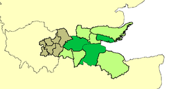
Gran Londres Desde la zona nordeste a la zona sudeste del Plano de Londres: los municipios de Barking y Dagenham, Bexley, Havering, Lewisham, Greenwich, Newham y Tower Hamlets
Este Basildon, Castle Point y Rochford (todos ellos distritos no metropolitanos de Essex), y las autoridades unitarias de Thurrock y Southend-on-Sea
Sudeste Dartford, Gravesham y Swale (todos ellos distritos no metropolitanos de Kent), y la autoridad unitaria de Medway.

Perfil

El área es hogar de alrededor de 1,6 millones de personas y contiene algunos de los distritos más pobres del país, caracterizado por una falta de acceso al transporte pùblico, servicios, al empleo, y a una calidad de vivienda aceptable. Sus límites fueron diseñados para englobar una parte del río que antes fue base para extensos terrenos dedicados al a industria, sirviendo a Londres y al Sudeste de Inglaterra, cuyo declive ha dejado un legado a gran escala de tierra abandonada y en ruinas.

Administración

El departamento para las communities y el gobierno local es responsable de coordinar el proyecto y desarrollarlo, el cual será repartido por tres agencias de desarrollo regionales, la London Development Agency, la agencia del Este de Inglaterra, y la agencia de desarrollo del Sudeste.

El objetivo del Thames Gateway es el de mejorar la economía de la región a través de la reconversión en una zona industrial y de agricultura. Es posible hacer una similitud entre este proyecto con el acaecido en París y su valle Marne, solo que aquí la extensión de terreno a cubrir será mucho mayor.


Wikimedia foundation. 2010.

Игры ⚽ Нужно решить контрольную?

Mira otros diccionarios:

  • Thames Gateway — The Thames Gateway is an area of land stretching 40 miles (60 km) east from inner East London on both sides of the River Thames and the Thames Estuary. The area, which includes much brownfield land, has been designated a national priority for… …   Wikipedia

  • Thames Gateway Bridge — The Thames Gateway Bridge is a proposed new crossing of the River Thames in East London.It is proposed to be built by 2013 and will connect Beckton in the London Borough of Newham with Thamesmead in the London Borough of Greenwich. It will… …   Wikipedia

  • Thames Gateway Transit — The Thames Gateway Transit is the collective name of two planned segregated bus schemes in the east London section of the Thames Gateway redevelopment zone in England. They are:*East London Transit *Greenwich Waterfront TransitIt is envisaged… …   Wikipedia

  • Thames Gateway Bridge — Vorgesehen gewesener Standort Die Thames Gateway Bridge war eine projektierte Straßenbrücke über den Fluss Themse in London. Sie sollte im Jahr 2013 eröffnet werden und Beckton im Stadtbezirk London Borough of Newham auf der Nordseite mit… …   Deutsch Wikipedia

  • London Thames Gateway Development Corporation — The London Thames Gateway Development Corporation (LTGDC) is a Non Departmental Public Body sponsored by the Department for Communities and Local Government, with directors appointed by the Secretary of State, including some democratically… …   Wikipedia

  • Thurrock Thames Gateway Development Corporation — is a Non Departmental Public Body sponsored by the Department for Communities and Local Government. It is an Urban Development Corporation set up by the Government of the United Kingdom covering the entire the borough and unitary authority of… …   Wikipedia

  • Gateway Bridge (disambiguation) — The term Gateway Bridge may refer to any of the following structures:*Gateway Bridge in Brisbane, Queensland, Australia *Gateway Bridge over the Mississippi River in Clinton, Iowa *Gateway Bridge in Brownsville, Texas *Thames Gateway Bridge is a… …   Wikipedia

  • Thames and Medway Canal — The Thames and Medway Canal is a disused canal in Kent, south east England, also known as the Gravesend and Rochester Canal. It was originally some 11 km (7 miles) long and cut across the neck of the Hoo peninsula, linking the River Thames at… …   Wikipedia

  • Thames Estuary — The Thames Estuary is the area in which the River Thames meets the waters of the North Sea.It is not easy to define the limits of the estuary [ [http://www.countryside.gov.uk/LAR/Landscape/CC/SEL/greater thames estuary.asp# Countryside Agency… …   Wikipedia

  • River Thames — Thames redirects here. For other uses, see Thames (disambiguation). Coordinates: 51°29′56″N 0°36′31″E / 51.4989°N 0.6087°E / 5 …   Wikipedia

Compartir el artículo y extractos

Link directo
Do a right-click on the link above
and select “Copy Link”