Ubiretama

Ubiretama
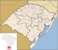
Ubiretama dentro del municipio de Rio Grande do Sul.

Ubiretama es un municipio brasileño del estado de Rio Grande do Sul. El origen del nombre surge de las lenguas tupí. Está ubicado 499 km al oeste de la capital del estado de Porto Alegre, al noreste de Alegrete y al este de la Argentina. Sus coordenadas son 28°2′45″S 54°40′51″O / -28.04583, -54.68083.

Su población estimada para el año 2004 era de 2.542 habitantes.

Ocupa una superficie de 126,7 km².

Enlaces externos


Wikimedia foundation. 2010.

Игры ⚽ Нужно решить контрольную?

Mira otros diccionarios:

  • Ubiretama — is a municipality of the western part of the state of Rio Grande do Sul, Brazil. The origin of the name comes from the Tupi language. It is located 499 km west of the state capital of Porto Alegre, northeast of Alegrete and east of… …   Wikipedia

  • Ubiretama — Admin ASC 2 Code Orig. name Ubiretama Country and Admin Code BR.23.4322343 BR …   World countries Adminstrative division ASC I-II

  • List of municipalities in Rio Grande do Sul — Municipalities of Rio Grande do Sul, Brazil This is a list of the municipalities in the state of Rio Grande do Sul (RS), Brazil. Mesoregion Microregion Municipality Centro Ocidental Rio Grandense Restinga Seca …   Wikipedia

  • Муниципалитеты штата Риу-Гранди-ду-Сул — …   Википедия

  • Убиретама — Муниципалитет Убиретама Ubiretama Страна БразилияБразилия …   Википедия

  • Montenegro, Rio Grande do Sul — This article is about a city in Brazil. For other places named Montenegro, see Montenegro (disambiguation). Montenegro is a city and municipality of the state of Rio Grande do Sul, Brazil; 59.000 inhabitants. The town was established in 1847 to… …   Wikipedia

  • List of postal codes in Brazil — These are list of postal codes in Brazil. Since 1993, the eight digit form was introduced, prior to 1993, the Brazilian postal codes formerly used the five digit form. Unlike the North American, some European and some other postal/ZIP codes, the… …   Wikipedia

  • Nova Petrópolis — Coordinates: 23°31′43″S 46°20′42″W / 23.52861°S 46.345°W / 23.52861; 46.345 …   Wikipedia

  • Novo Hamburgo — City of Novo Hamburgo From upper left: Ernesto Frederico Scheffel Foundation, Cathedral Basilica of St. Louis Gonzaga, Monument to the Shoemaker, Friedrich Museum, Schmitt Presser Museum, and Panoramic view of Novo Hamburgo …   Wikipedia

  • Osório — is a city in Rio Grande Do Sul, Brazil. Its population is about 40,000 inhabitants. Osório is situated 90 km east of Porto Alegre. In 2006, a Spanish company, Enerfin, built the largest and most modern aeolic energy generation park in Latin… …   Wikipedia

Compartir el artículo y extractos

Link directo
Do a right-click on the link above
and select “Copy Link”