- Attiswil
-
Attiswil
Attiswil 
Escudo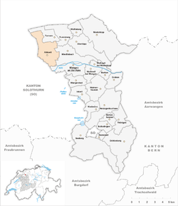
País  Suiza
Suiza• Cantón  Berna
Berna• Distrito Wangen Ubicación • Altitud 464 msnm Superficie 7,7 km² Población 1325 hab. (2007) • Densidad 172 hab./km² Lengua Alemán Código postal 4536Attiswil es una comuna suiza del cantón de Berna, situada en el distrito de Wangen. Limita al norte con la comuna de Farnern, al este con Rumisberg y Wiedlisbach, al sur con Wangen an der Aare, y al oeste con Flumenthal (SO), Günsberg (SO), Hubersdorf (SO) y Kammersrohr (SO).
Categoría: Localidades de Berna


Wikimedia foundation. 2010.