Coeroeni

Coeroeni
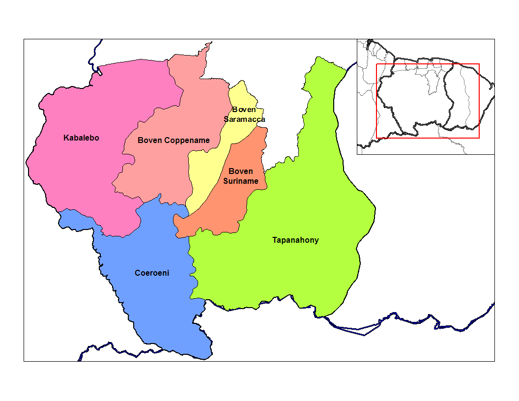
Suburbios del distrito de Sipaliwini, en color azul se muestra a Coeroenie

Coeroenie (algunos lo escriben Coeroeni) es uno de los sububios en que se divide el distrito de sipaliwini, en Surinam. Este suburbio queda demarcado por el cauce del río Coeroeni.

Al este linda con el suburbio de Tapanahoni, mientras que al sur se encuentra la frontera con Brasil. Por el oeste se encuentra la frontera con Guyana, el extremo oeste del suburbio es la región de Tigri la cual es objeto de una disputa pro demarcación de la frontera con Guyana. Hacia el norte se encuentran los suburbios de Kabalebo y Boven Coppename y en noroeste los suburbios de Boven Saramacca y Boven Suriname.

Según los datos del censo del año 2004 Coeroenie posee una población de 1.299 habitantes. Las localidades más populosas del suburbio son Kwamalasamutu, Anapi y Alalapadu.


Wikimedia foundation. 2010.

Игры ⚽ Нужно решить контрольную?

Mira otros diccionarios:

  • Coeroeni —   Resort   Map showing the resorts of Sipaliwini District. Country …   Wikipedia

  • Coeroeni — Sp Kurūnis Ap Coeroeni L u. Gajanos ir Surinamo pasienyje …   Pasaulio vietovardžiai. Internetinė duomenų bazė

  • Coeroeni River — The Coeroeni River is a river in South America. It arises in the northwestern part of Pará, Brazil, and flows northward remaining in Brazil for only a few kilometres. The Coeroeni goes on to form the southern half of the international boundary… …   Wikipedia

  • Corantijn — Der Corantijn (Engl.: Courantyne) ist ein Fluss in Südamerika. Er bildet die Grenze zwischen Guyana und Suriname, gehört aber laut Schiedsgerichtspruch vollständig zum surinamischen Staatsgebiet. Inhaltsverzeichnis 1 Flussverlauf 2 Besonderheiten …   Deutsch Wikipedia

  • Guyana — Cooperative Republic of Guyana República Cooperativa de Guyana …   Wikipedia Español

  • Sipaliwini — Distrito de Surinam Entidad Distrito …   Wikipedia Español

  • Courantyne River — or Corantijn or Coeroeni River, northern South America. Rising in the Akarai Mountains, it flows north for 450 mi (700 km) and empties into the Atlantic Ocean near Nieuw Nickerie, Suri. It divides Suriname and Guyana; residents of the latter are… …   Universalium

  • Districts of Suriname — Suriname This article is part of the series: Politics and government of Suriname Constitution President …   Wikipedia

  • Commewijne District — Map of Suriname showing Commewijne district Commewijne is a district of Suriname, located on the right bank of the Suriname River. Commewijne s capital city is Nieuw Amsterdam. Alliance is another major town. The district has a population of… …   Wikipedia

  • Coronie District — Map of Suriname showing Coronie district Coronie is a district of Suriname, situated on the coast. Coronie s capital city is Totness, with other towns including Corneliskondre, Friendship, Jenny. The district border the Atlantic Ocean to the… …   Wikipedia

Compartir el artículo y extractos

Link directo
Do a right-click on the link above
and select “Copy Link”