- Comendador Gomes
-
Comendador Gomes 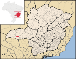
MapaCoordenadas: Coordenadas: Entidad Municipio • País  Brasil
• Estado Minas Gerais • Mesorregión Triángulo Minero/Alto Paranaíba • Microrregión Frutal • Fundación 27 de diciembre de 1948 Superficie • Total 1.042,882 km²[1] Población (Censo IBGE/2010[2] ) • Total 2.972 hab. • Densidad 2,85 hab/km² PIB (nominal) • Total 80.274,708 mil • PIB per cápita 24953.28 IDH (PNUD/2000[3] ) 0.795 Datos mesorregión IBGE/2008[4] Datos microrregión IBGE/2008[4] Municipios vecinos Prata, Itapagipe, Frutal, Campo Florido, Campina Verde Comendador Gomes es un municipio brasileño del estado de Minas Gerais. Su población estimada en 2004 era de 2.779 habitantes.
Referencias
- ↑ . Resolução da Presidência do IBGE de n° 5 (R.PR-5/02) (10 out. 2002). Consultado el 5 diez. 2010.
- ↑ . Instituto Brasileiro de Geografia e Estatística (IBGE) (29 de noviembre de 2010). Consultado el 11 de diciembre de 2010.
- ↑ «Ranking decreciente del IDH-M de los municipios del Brasil». Programa das Nações Unidas para o Desenvolvimento (PNUD) (2000). Consultado el 11 de octubre de 2008.
- ↑ a b «División Territorial del Brasil». Instituto Brasileiro de Geografia e Estatística (IBGE) (1 de julio de 2008). Consultado el 11 de octubre de 2008.
- Este artículo fue creado a partir de la traducción automática del artículo Comendador Gomes de la Wikipedia en portugués, concretamente de esta versión, bajo licencia Creative Commons Atribución Compartir Igual 3.0 y GFDL.
Categoría:- Localidades de Minas Gerais

Wikimedia foundation. 2010.