- GeoServer
-
GeoServer 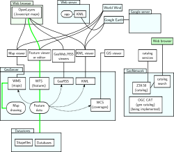
GeoServer GeoNetwork con una aplicación webDesarrollador OpenGeo, GeoSolutions, Refractions Research
http://geoserver.orgInformación general Última versión estable 2.0.2
25 de mayo de 2010Género Servidor en el seno de un Sistema de información geográfica Programado en Java Sistema operativo GNU/Linux, MS-Windows, Mac OS X, sistemas operativos que cumplan estándares POSIX Plataforma Java Licencia GPL Idiomas inglés En español 
En computación, GeoServer - un servidor de código abierto escrito en Java - permite a los usuarios compartir y editar datos geospaciales. Diseñado para la interoperabilidad, publica datos de cualquier gran fuente de datos del espacio usando estándares abiertos. GeoServer ha evolucionado hasta llegar a ser un método sencillo de conectar información existente a globos virtuales tales como Google Earth y NASA World Wind (véase así como mapas basados en web como OpenLayers, Google Maps y Bing Maps. GeoServer sirve de implementación de referencia del estándar Open Geospatial Consortium Web Feature Service, y también implementa las especificaciones de Web Map Service y Web Coverage Service.
Contenido
Objetivos
GeoServer pretende operar como un nodo a través de una Infraestructura de Datos Espaciales libre y abierta para ofrecer datos geoespaciales, tal y como ha hecho Apache HTTP Server ofreciendo un servidor web abierto y libre para publicar HTML.
Características principales
Entre las principales características de Geoserver se pueden citar algunas como:
- Enteramente compatíble con las especificaciones WMS, WCS e WFS, testados por el test de conformidad CITE de la OGC.
- Fácil utilización a través de la herramienta de administración vía web -no es necesario entrar en archivos de configuración grandes y complicados-.
- Soporte amplio de formatos de entrada PostGIS, Shapefile, ArcSDE y Oracle. VFP, MySQL, MapInfo y WFS en cascada también están entre los formatos de entrada soportados (véase más abajo).
- Soporte de formatos de salida tales como JPEG, GIF, PNG, SVG y GML.
- Imágenes con antialiasing.
- Soporte completo de SLD, como definiciones del usuario (POST y GET), y como uso de configuración de estilos.
- Soporte para edición de datos de banco de datos individuales a través del protocolo WFS transactional profile (WFS-T), disponible para todos los formatos de datos.
- Basado en servlets Java (JEE), puede funcionar en cualquier servlet contenedor.
- Proyectado para ser compatible con extensiones.
- Facilidad de escritura de nuevos formatos de datos con la interfaz de almacenamiento de datos GeoTools y clases de ayuda.
Además, GeoServer incluye un cliente integrado OpenLayers para previsualizar capas de datos. GeoServer también soporta la publicación de datos geoespaciales para Google Earth a través del uso de enlaces de red, utilizando KML para ello. Funciones avanzadas disponibles para output de Google Earth incluyen plantillas para pop-ups personalizados, visualizado de altitud y longitud, y "super-overlays".
GeoServer se basa en GeoTools, una biblioteca de sistemas de información geográfica.
Formatos
GeoServer lee una amplia variedad de formatos de archivo, incluyendo: Entre los formatos de entrada aceptados se encuentran los siguientes:
Entre los formatos de salida en los cuales GeoServer Web Map Service es capaz de producir archivos a través de protocolos estándar, se encuentran los siguientes:
y otros.
Uso
Las siguientes instituciones usan GeoServer:
- MassGIS (Massachusetts state GIS)
- TriMet (Transit agency for Portland, Oregon)
- Ordnance Survey (National Mapping Agency of the UK)
- Institut Géographique National (National Mapping Agency of France)
- GBIF (Global Biodiversity Information Facility)
- Banco mundial
- Global Earthquake Model
- FAO (Food and Agriculture Organization of the United Nations)
- New York City Department of Information Technology and Telecommunications
Arquitectura
GeoServer usa Restlet como framework para los servicios REST que proporciona. Incluye Jetty como servidor embebido, pero soporta cualquier servlet container común. GeoWebCache, un componente de cacheado basado en Java similar a TileCache, se incluye con GeoServer, aunque también está disponible por separado.[1]
Notas
- ↑ «GeoWebCache».
Véase también
- Sistema de información geográfica
- Open Geospatial Consortium
- Web Feature Service
- Web Map Service
- Web Coverage Service
- OpenLayers
- GeoTools
- MapServer
- OpenGeo
- Refractions Research
- GeoSolutions
Enlaces externos
- (en inglés) Sitio web oficial de GeoServer
- (en inglés) Blog de GeoServer
- (en inglés) OpenPlans (creadores originales de GeoServer)
- (en inglés) OpenGeo División de consultoría geoespacial de The Open Planning Project
Categorías:- Software de globo terráqueo virtual
- Software libre programado en Java
- Tecnología geográfica
- Sistemas de Información Geográfica
- Software libre de SIG

Wikimedia foundation. 2010.