Gongogi

Gongogi
Gongogi
Himno: http://sites.google.com/site/soudegongogi/hino-de-gongogi
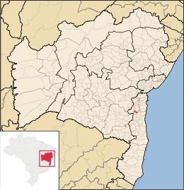
Mapa
Mapa
Coordenadas: 14°19′19″S 39°27′54″O / -14.32194, -39.465Coordenadas: 14°19′19″S 39°27′54″O / -14.32194, -39.465
Entidad Municipio
 • País Bandera de Brasil Brasil
 • Estado Bahía
 • Mesorregión Sur Bahiano
 • Microrregión Ilhéus-Itabuna
 • Fundación 12 de abril de 1962
Superficie  
 • Total 198,305 km²[1]
Población (IBGE/2010[2] )  
 • Total 8.344 hab.
 • Densidad 42,08 hab/km²
Gentilicio Gongogiense
PIB (nominal)  
 • Total 23.518,681 mil
 • PIB per cápita 3573.72
IDH (PNUD/2000[3] ) 0.586
Datos mesorregión IBGE/2008[4]
Datos microrregión IBGE/2008[4]
Municipios vecinos Ubatã/Aurelino Leal

Gongogi es un municipio brasileño del estado de Bahía. Su población estimada en 2004 era de 11.328 habitantes.

Referencias

  1. . Resolução da Presidência do IBGE de n° 5 (R.PR-5/02) (10 out. 2002). Consultado el 5 diez. 2010.
  2. . Instituto Brasileiro de Geografia e Estatística (IBGE) (29 de noviembre de 2010). Consultado el 11 de diciembre de 2010.
  3. «Ranking decreciente del IDH-M de los municipios del Brasil». Programa das Nações Unidas para o Desenvolvimento (PNUD) (2000). Consultado el 11 de octubre de 2008.
  4. a b «División Territorial del Brasil». Instituto Brasileiro de Geografia e Estatística (IBGE) (1 de julio de 2008). Consultado el 11 de octubre de 2008.

Wikimedia foundation. 2010.

Игры ⚽ Нужно решить контрольную?

Mira otros diccionarios:

  • Gongogi — Sp Gongoži nkt. Ap Gongogi L u. Brazilijoje (Baija) …   Pasaulio vietovardžiai. Internetinė duomenų bazė

  • Gongogi — Admin ASC 2 Code Orig. name Gongogi Country and Admin Code BR.05.2911501 BR …   World countries Adminstrative division ASC I-II

  • Муниципалитеты штата Баия — …   Википедия

  • Гонгожи — Муниципалитет Гонгожи Gongogi Страна БразилияБразилия …   Википедия

  • Mirante — is a municipality/county in the state of Bahia in Brazil. In 2004 it had a population of 16,476. See also Mirante do Paranapanema, in São Paulo v …   Wikipedia

  • Cruz das Almas — is a small city near Salvador, in the state of Bahia, in Brazil. In 2004, it had an estimated population of 56.000 inhabitants. Its climate is tropical, hot and humid. The economy is based on agriculture, especially tobacco, orange and cassava… …   Wikipedia

  • Morro do Chapéu — is a small city in the Brazilian state of Bahia, 386 km northwest of its capital, Salvador, 1012 meters above the sea level, because of which it is one of the coolest towns in Bahia, with temperatures occasionally falling below 10 °C in the… …   Wikipedia

  • Correntina — is a town in the state of Bahia in Brazil, 500 km from Brasilia and 980 km from Salvador. History Correntina was first mentioned in the dispatches of the Entradistas and Bandereirantes who visited the city in 1700 and 1790. The Decree… …   Wikipedia

  • Mucuri — Curaçá   Municipality   The Municipality of Curaçá Costa Dourada beach and its cliffs: the first beach in Bahia from so …   Wikipedia

  • Conceição do Almeida — Location of Conceição do Almeida Coordinates …   Wikipedia

Compartir el artículo y extractos

Link directo
Do a right-click on the link above
and select “Copy Link”