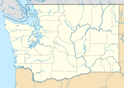
Grays River (Washington) — Grays River is a tributary of the Columbia River, approximately 20 miles (32 km) long, in southwestern Washington in the United States. One of the lowest tributaries of the Columbia on the Washington side, it drains an area of low hills north of… … Wikipedia
Grays River, Washington — Grays River is an unincorporated rural village in Wahkiakum County, Washington, United States.Grays River stands on the north bank of the lower Grays River, which flows into the Columbia River estuary. The National Register of Historic Places… … Wikipedia
Grays River — bezeichnet einen Fluss in Neuseeland, siehe Grays River (Neuseeland) einen Zufluss des Columbia River im US Bundesstaat Washington, siehe Grays River (Washington) eine ländliche Gemeinde im US Bundesstaat Washington, siehe Grays River (Ort in… … Deutsch Wikipedia
Grays River — may refer to:*Grays River (Washington), a tributary of the lower Columbia River *Grays River, Washington, an unincorporated community on the Grays River *Grays River, New Zealand, a river in New Zealand … Wikipedia
Grays River Covered Bridge — Infobox nrhp | name =Grays River Covered Bridge nrhp type = caption = nearest city= Grays River, Washington lat degrees = 46 lat minutes = 21 lat seconds = 17.46 lat direction = N long degrees = 123 long minutes = 34 long seconds = 46.87 long… … Wikipedia
Grays Point (Washington) — Grays Point is the western, downstream point of Grays Bay, on the north shore of the Columbia River estuary, at River Mile 20 (measured from the estuary mouth), in Washington State, United States of America. Grays Point sticks out slightly and… … Wikipedia
Chehalis River (Washington) — Chehalis River Chehalis River Valley (links), Grays Harbor (Bildmitte) und Satsop River Valley (Bildvordergrund)Vorlage:Infobox Fluss … Deutsch Wikipedia
Deep River, Washington — For other uses, see Deep River (disambiguation). Deep River, Washington Unincorporated community … Wikipedia
Chehalis River (Washington) — For other places with the same name, see Chehalis River (disambiguation). Coordinates: 46°57′29″N 123°50′5″W / 46.95806°N 123.83472°W / … Wikipedia
North River (Washington) — The North River before emptying into Willapa Bay. The North River is a river, approximately 30 miles (48 km) long, in western Washington, in the United States. It empties into Willapa Bay, the first large estuary on the Washington coast… … Wikipedia
 Grays River
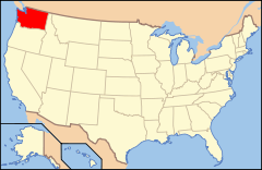
 Estados Unidos
 Washington
 Portal:Washington. Contenido relacionado con Washington.
 Wikimedia Commons alberga contenido multimedia sobre Grays River (Washington). Commons
