Kabalebo

Kabalebo
Kabalebo
Sipaliwini resorts.png
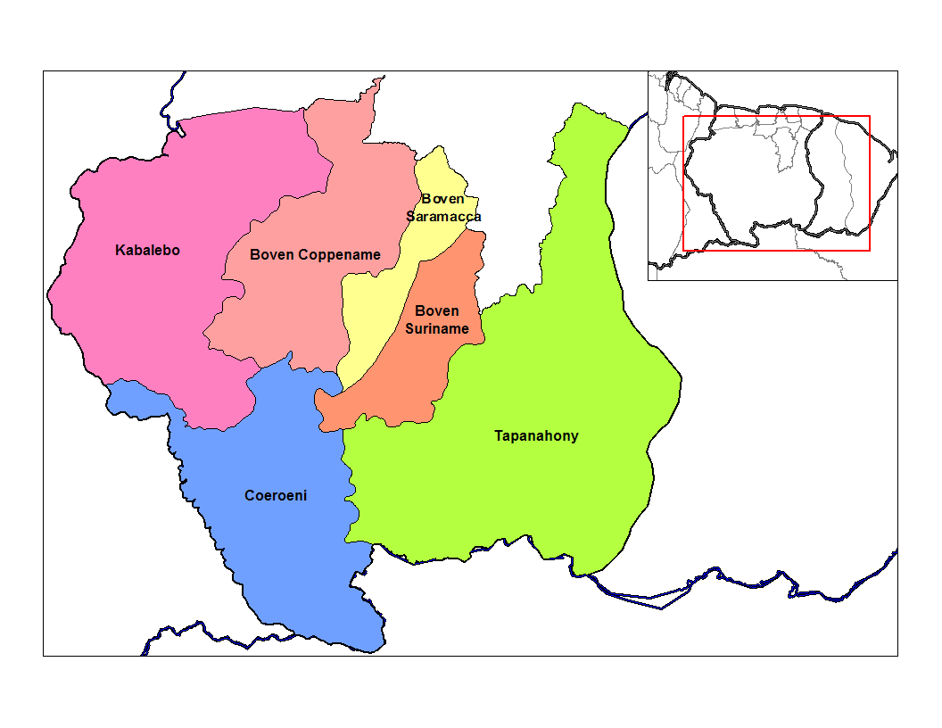
Distrito de Sipaliwini con Kabalebo en rosado oscuro
País Surinam
• Distrito Sipaliwini
• Suburbio Kabalebo
Población 1,843[1] hab. (2004)
Huso horario UTC-3

Kabalebo es una de los seis suburbios en los que se divide el distrito de Sipaliwini, en Surinam. Está ubicado al extremo occidente del país. Toma el nombre del Río Kabalebo.

Limita al norte con los distritos de Nickerie, al oriente con el suburbio de Boven Coppename, al sur limita con el suburbio de Coeroeni y al occidente con Guyana.

Para el 2004, Kabalebo según cifras de la Oficina Central de Asuntos Civiles (CBB), tenía 1,843 habitantes. Algunas de las localidades más grandes en este suburbio son Apoera y Bakhuis.

Referencias

  1. «Datos estadísticos de Kabalebo en statoids.com» (en inglés). Consultado el 11 de junio de 2010.

Wikimedia foundation. 2010.

Игры ⚽ Поможем написать курсовую

Mira otros diccionarios:

  • Liste der größten Stauseen der Erde — Die Liste der größten Stauseen der Erde zeigt einer Auswahl der größten Stauseen der Erde und im deutschsprachigen Raum sortiert nach Flächen und Volumengröße. Ein Stausee ist per definitionem ein künstlich angelegter Wasserspeicher, der sich in… …   Deutsch Wikipedia

  • Aeropuertos de Surinam — Anexo:Aeropuertos de Surinam Saltar a navegación, búsqueda Lista de aeropuertos de Surinam, organizados por ciudad. Contenido 1 Lista 2 Véase también 3 Referencias …   Wikipedia Español

  • Sipaliwini — Distrito de Surinam Entidad Distrito …   Wikipedia Español

  • Major World Dams Under Construction in 1993* — ▪ Table Length Volume Gross of content reservoir Height crest (000 capacity Name of dam River Country Type** (m) (m) cu m) (000 cu m) Al Wahda Fez Morocco E 88 1,600 27,000 3,800,000 Al Wehda Yarmuk Jordan/Syria E,R 164 700 21 …   Universalium

  • Operation Grasshopper — …   Wikipedia

  • Anexo:Aeropuertos de Surinam — Lista de aeropuertos de Surinam, organizados por ciudad. Contenido 1 Lista 2 Véase también 3 Referencias 4 Enlaces externos …   Wikipedia Español

  • Economy of Suriname — Infobox Economy country = Suriname width = 250 caption = Hardwood logs transported down river, 1955 currency = Surinamese dollar (SRD) year = calendar year organs = WTO, Unasur rank = 176th gdp = $2.818 billion (2005 est.) growth = 2% (2005 est.) …   Wikipedia

  • Districts of Suriname — Suriname This article is part of the series: Politics and government of Suriname Constitution President …   Wikipedia

  • Commewijne District — Map of Suriname showing Commewijne district Commewijne is a district of Suriname, located on the right bank of the Suriname River. Commewijne s capital city is Nieuw Amsterdam. Alliance is another major town. The district has a population of… …   Wikipedia

  • Coronie District — Map of Suriname showing Coronie district Coronie is a district of Suriname, situated on the coast. Coronie s capital city is Totness, with other towns including Corneliskondre, Friendship, Jenny. The district border the Atlantic Ocean to the… …   Wikipedia

Compartir el artículo y extractos

Link directo
Do a right-click on the link above
and select “Copy Link”