- Ober Gabelhorn
-
Ober Gabelhorn 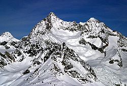
Ober Gabelhorn (izquierda) y Wellenkuppe (derecha).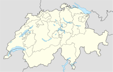
 Ober Gabelhorn
País  Suiza
SuizaCoordenadas Coordenadas: Altitud 4.063 msnm Cordillera Alpes Peninos Prominencia 405 m Primera ascensión 6 de julio de 1865, por Adolphus Warburton Moore, Horace Walker y Jakob Anderegg. El Ober Gabelhorn también Obergabelhorn (4.063 m) es una montaña suiza en los Alpes Peninos. Se encuentra en el cantón del Valais a lo largo de la cresta que separa el Mattertal del valle de Zinal.
Contenido
Características
La montaña forma parte de la llamada corona imperial, junto con montañas que forman una herradura: Les Diablons (3.609 m), el Bishorn (4.153 m), el Weisshorn (4.505 m), el Schalihorn (3.974 m), el Zinalrothorn (4.221 m), el Trifthorn (3.728 m), el Obergabelhorn (4.062 m), el mont Durand (3.712 m), la Pointe de Zinal (3.790 m), la Dent Blanche (4.356 m), el Grand Cornier (3.961 m), el Pigne de la Lé (3.396 m), y Gardes de Bordon (3.310 m), y en el centro de esta gigantesca parábola el Monte Besso (3.667 m).
Historia
El primer ascenso a la cima fue completada el 6 de julio de 1865 por A. W. Moore, Horace Walker y Jakob Anderegg.
Refugios
Para facilitar el ascenso a la cima y el excursionismo en torno al monte existen algunos refugios:
- Rothorn Hutte - 3.198 m
- Cabaña de Mountet - 2.886 m
- Vivac Arben - 3.224 m.
Clasificación SOIUSA
Según la clasificación SOIUSA, el Ober Gabelhorn pertenece:
- Gran parte: Alpes occidentales
- Gran sector: Alpes del noroeste
- Sección: Alpes Peninos
- Subsección: Alpes del Weisshorn y del Cervino
- Supergrupo: Cadena Weisshorn-Zinalrothorn
- Grupo: Grupo Ober Gabelhorn-Zinalrothorn
- Código: I/B-9.II-D.7
Referencias
- Este artículo fue creado a partir de la traducción del artículo Obergabelhorn de la Wikipedia en italiano, bajo licencia Creative Commons Atribución Compartir Igual 3.0 y GFDL.
Enlaces externos
 Wikimedia Commons alberga contenido multimedia sobre Ober Gabelhorn. Commons
Categorías:- Montañas del Valais
- Alpes Peninos
- Cuatromiles de los Alpes


Wikimedia foundation. 2010.