Ogurja Ada

Ogurja Ada
Ogurja Ada
Ogurga /Огурчинский
Localización
País Bandera de Turkmenistán Turkmenistán
Provincia Provincia de Balkan
Mar Mar Caspio
Coordenadas 38°97′N 53°05′E / 39.617, 53.083Coordenadas: 38°97′N 53°05′E / 39.617, 53.083
Geografía
Superficie 45 km²
Largo máximo 47 km
Ancho máximo 3 km
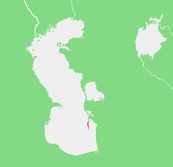
Caspian5OGU.png
Mapa de localización de la isla

Ogurja Ada[1] (a veces también escrito "Ogurga") es la isla más grande de Turkmenistán y la que tiene más longitud en el Mar Caspio. La isla Ogurja es también ampliamente conocida por su nombre ruso Isla Ogurchinskiy (Огурчинский o bien Ostrov Ogurchinskiy[2] ).

Ogurja se encuentra en las zona costera del sudeste del Mar Caspio. Aproximadamente a 17 kilómetros en el extremo sur de la Península Cheleken.

Ogurja Ada es muy larga y estrecha. Corre de norte a sur, con una longitud de 47 km y una anchura máxima de 3 km.

Administrativamente Ogurja Ada pertenece a la Provincia de Balkan (Balkan welaýaty / Балкан велаяты) de Turkmenistán. Su área total es de cerca de 45 km².

Véase también

Referencias

Enlaces externos


Wikimedia foundation. 2010.

Игры ⚽ Поможем написать реферат

Mira otros diccionarios:

  • Ogurja Ada — Location of Ogurja Ada. 19th century Russian map of Ogurchinskiy Island …   Wikipedia

  • Balkan Province — (Balkan welaýaty / Балкан велаяты) is one of the Welayatlar (provinces) of Turkmenistan. It is in the far west of the country, bordering Uzbekistan, Kazakhstan, the Caspian Sea, and Iran. Its capital is Balkanabat, formerly known as Nebit Dag. It …   Wikipedia

  • Caspian Sea — As captured by …   Wikipedia

  • Île Ogurchinskiy — 38°30′N 53°04′E / 38.5, 53.067 …   Wikipédia en Français

  • Pirallahi Island — Pirallahi Pirallahi Island off the Apsheron Peninsula Geography Location Caspian Sea Coordinates …   Wikipedia

  • Chilov — Map showing Chilov Island off the eastern tip of the Apsheron Peninsula. Chilov (Azerbaijani: Çilov adası, also spelt Zhiloy and Jiloi) is an island off the Absheron Peninsula, 55 km east of Baku. Chilov Island is located 25 km off the eastern… …   Wikipedia

  • Chistoy Banki — or Chistaya Banka is an island in the Caspian Sea. It is located off the mouths of the Volga, 27 km south of the southern tip of Zyudev Island. Chistoy Banki Island has a length of 6 km and a maximum width of 4 km. Administratively …   Wikipedia

  • Chechen Island — Location of Chechen Island. Chechen Island (Остров Чечень; Ostrov Chechen ), is a coastal island in the Caspian Sea. It is located 20 km east of Krainovka right off a landhead on the western shore of the Caspian. The island has a length of… …   Wikipedia

  • Chikil — Map showing the location of the Baku Archipelago. Chikil, also known as Oblivnoy, is an uninhabited island off the Bay of Baku, Azerbaijan. This island is part of the Baku Archipelago, which consists of the following islands: Boyuk Zira, Dash… …   Wikipedia

  • Durneva Island — or Dūrnev Araldary (Russian: Ostrov Durnëva) is a coastal island on the shores of the Shyghanaghy Bay (Komsomolets Bay) of the eastern Caspian Sea. It is located east of the Mangyshlak Peninsula and 41.6 km north of Turum. Administratively… …   Wikipedia

Compartir el artículo y extractos

Link directo
Do a right-click on the link above
and select “Copy Link”