Oostelijke Polders

Oostelijke Polders
Oostelijke Polders
Nickerie resorts.png
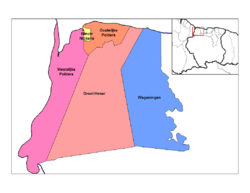
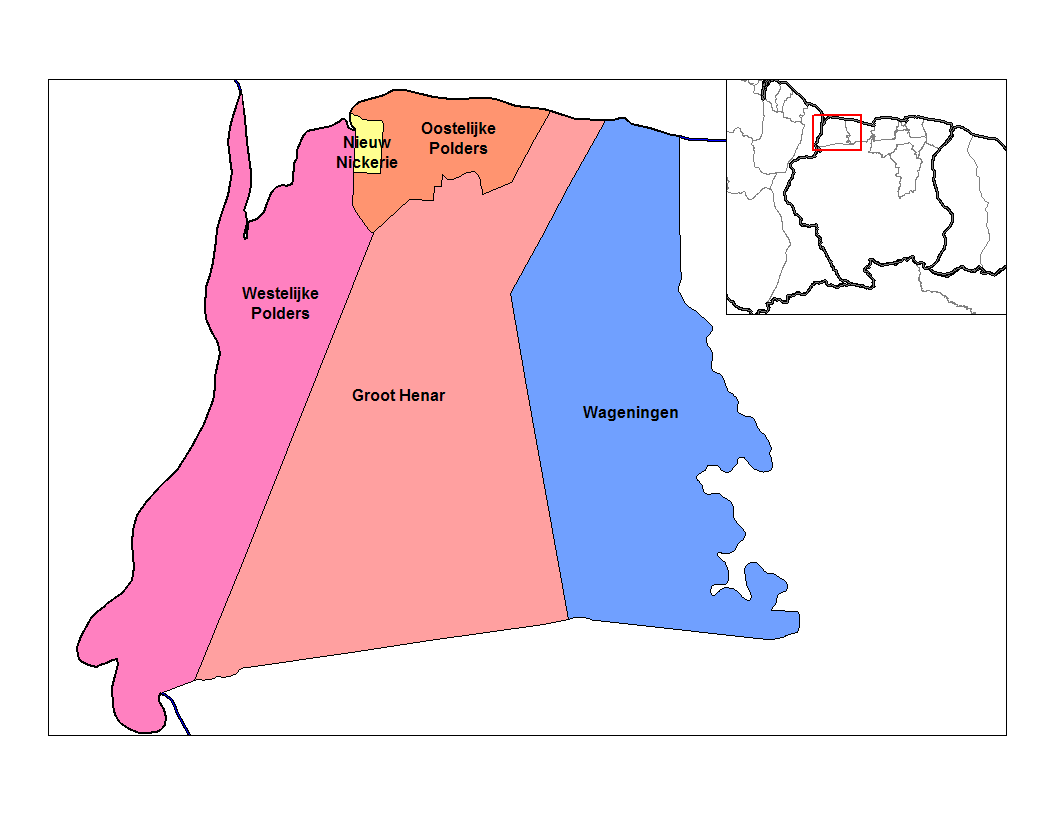
Distrito de Nickerie con Oostelijke Polders en naranja oscuro.
País Surinam Bandera de Surinam
• Distrito Nickerie
• Suburbio Oostelijke Polders
Población 6,778[1] hab. (2004)
Huso horario UTC-3

Oostelijke Polders es una de los cinco suburbios en los que se divide el distrito de Nickerie, en Surinam.[2]

Limita al norte con el Océano Atlántico, al oriente y al sur con el suburbio de Groot Henar y al occidente con los suburbios Westelijke Polders y Nieuw Nickerie.

Para el 2004, Oostelijke Polders según cifras de la Oficina Central de Asuntos Civiles (CBB), tenía 6,778 habitantes.

Véase también

  • Nieuw Amsterdam

Referencias

  1. «Datos estadísticos de Oostelijke Polders en statoids.com» (en inglés). Consultado el 30 de junio de 2010.
  2. Suriname.nu. «Sobre el estado de Nickerie» (en neerlandés). Consultado el 30 de junio de 2010.

Wikimedia foundation. 2010.

Игры ⚽ Нужна курсовая?

Mira otros diccionarios:

  • Oostelijke Polders —   Resort   Map showing the resorts of Nickerie District. Country …   Wikipedia

  • Westelijke Polders — Distrito de Nickerie con Westelijke Polder …   Wikipedia Español

  • Nickerie District — Map of Suriname showing Nickerie district Nickerie is a district of Suriname, on the north west coast. Nickerie s capital city is Nieuw Nickerie, the second largest city in the country. Other towns include Washoda and Wageningen. The district… …   Wikipedia

  • Nickerie — Capital Nieuw Nickerie Entidad Distrito …   Wikipedia Español

  • Districts of Suriname — Suriname This article is part of the series: Politics and government of Suriname Constitution President …   Wikipedia

  • Commewijne District — Map of Suriname showing Commewijne district Commewijne is a district of Suriname, located on the right bank of the Suriname River. Commewijne s capital city is Nieuw Amsterdam. Alliance is another major town. The district has a population of… …   Wikipedia

  • Coronie District — Map of Suriname showing Coronie district Coronie is a district of Suriname, situated on the coast. Coronie s capital city is Totness, with other towns including Corneliskondre, Friendship, Jenny. The district border the Atlantic Ocean to the… …   Wikipedia

  • Marowijne District — Map of Suriname showing Marowijne district Marowijne is a district of Suriname, located on the north east coast. Marowijne s capital city is Albina, with other towns including Moengo and Wanhatti. The district borders the Atlantic Ocean to the… …   Wikipedia

  • Saramacca District — Coordinates: 5°46′57″N 55°37′29″W / 5.7825°N 55.62472°W / 5.7825; 55.62472 …   Wikipedia

  • Moengo —   Resort   Map showing the resorts of Marowijne District …   Wikipedia

Compartir el artículo y extractos

Link directo
Do a right-click on the link above
and select “Copy Link”