- Ouriçangas
-
Ouriçangas 
Bandera
Escudo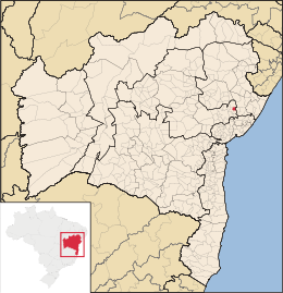
MapaCoordenadas: Coordenadas: Entidad Municipio • País  Brasil
• Estado Bahía • Mesorregión Centro Norte Bahiano • Microrregión Feria de Santana Fundación 27 de marzo • Fundación 27 de marzo de 1962 Superficie • Total 148,166 km²[1] Clima tropical atlántico Población (IBGE/2010[2] ) • Total 8.287 hab. • Densidad 55,93 hab/km² Gentilicio ouriçanguense PIB (nominal) • Total 23.531,557 mil • PIB per cápita 2911.96 IDH (PNUD/2000[3] ) 0.618 Datos mesorregión IBGE/2008[4] Datos microrregión IBGE/2008[4] Municipios vecinos Aramari, Pedrão, Água Fria e Irará Dist. Cap. 143 Ouriçangas es un municipio brasileño del estado de Bahía. Su población estimada en 2004 era de 7.772 habitantes.
Etimología
Ouriçangas viene del tupí guaraní, que significa "fuente de agua fresca"
Referencias
- ↑ . Resolução da Presidência do IBGE de n° 5 (R.PR-5/02) (10 out. 2002). Consultado el 5 diez. 2010.
- ↑ . Instituto Brasileiro de Geografia e Estatística (IBGE) (29 de noviembre de 2010). Consultado el 11 de diciembre de 2010.
- ↑ «Ranking decreciente del IDH-M de los municipios del Brasil». Programa das Nações Unidas para o Desenvolvimento (PNUD) (2000). Consultado el 11 de octubre de 2008.
- ↑ a b «División Territorial del Brasil». Instituto Brasileiro de Geografia e Estatística (IBGE) (1 de julio de 2008). Consultado el 11 de octubre de 2008.
- Este artículo fue creado a partir de la traducción automática del artículo Ouriçangas de la Wikipedia en portugués, concretamente de esta versión, bajo licencia Creative Commons Atribución Compartir Igual 3.0 y GFDL.
Enlaces externos
Categoría:- Localidades de Bahía


Wikimedia foundation. 2010.