- Pulau Sekudu
-
Isla Sekudu
Pulau Sekudu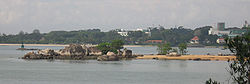
Localización País  Singapur
Coordenadas Coordenadas: Geografía La Isla Sekudu ( en inglés: Sekudu Island; Chino: 岛 青蛙; en malayo: Pulau Sekudu), también conocida como la Isla de la rana (Frog Island), es un islote situado al lado de Chek Jawa en Pulau Ubin, Singapur. Se encuentra en el puerto de Serangoon al frente de Changi. A pesar de su proximidad, se puede llegar por barco, incluso en las mareas bajas.
Cuenta la leyenda local que tres animales de Singapur - un cerdo, un elefante y una rana - hicieron un desafío para ver quién podía llegar a la orilla de Johor en primer lugar. Sea cual fuese el animal que no pudiere llegar a la costa se convertíria en roca. Las tres criaturas tenían dificultades para nadar, y mientras que la rana se convirtió en Pulau Sekudu, tanto el cerdo como el elefante se convirtieron en una isla más grande, Pulau Ubin.[1]
Véase también
Referencias
Enlaces externos
- Sekudu en wildsingapore (inglés)
Categoría:- Archipiélagos e islas de Singapur

Wikimedia foundation. 2010.