- Snaefell Mountain Course
-
Mountain Course 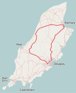
Localización Douglas, Isla de Man Eventos TT Isla de Man; Manx Grand Prix Longitud Km 60,73 Longitud Mi 37,733 Curvas Más de 200 17' 12,30 - 211,754 km/h (John McGuinness, Honda, 2009) Vuelta récord Snaefell Mountain Course o Mountain Course[1] es un circuito en carretera usado para el TT Isla de Man y el Manx Grand Prix, que se vienen llevando a cabo en la Isla de Man desde 1911 y 1923 respectivamente. La competicion se realiza en carreteras públicas cerradas al tráfico para este propósito, según un acta del Tynwald (el nombre del parlamente manés). Es el circuito de motociclismo que todavía está en uso más antiguo del planeta.
El circuito tiene un recorrido de 60,73 km de cuerda,[2] y su línea de salida se encuentra en la carretera A2, llamada Glencrutchery Road, en la ciudad de Douglas. El circuito está basado en un número de carreteras públicas de la isla, incluyendo la A2 de Douglas a Ramsey, la carretera A1 de Douglas a Peel, la carretera A3 desde Castletown a Ramsey y la carretera principal A18, que escala el Snaefell. El punto más alto del circuito se sitúa en esta última carretera, entre Bungalow y Hailwood's Height, con una cota de 422 metros sobre el nivel del mar ).
Contenido
Historia
Las competiciones de motor se iniciaron en la Isla de Man hacia 1904 con el Trial Gordon Bennett y estaba originalmente concebido exclusivamente para automóviles de turismo. Tras el Motor Car Act 1903, y que este legalizara un límite de velocidad de 20 millas por hora para los automóviles en el Reino Unido, el Secretario del Automobile Car Club of Britain and Ireland solicitó a las autoridades de la Isla de Man un permiso para competir por las carreteras públicas.[3] La ley del Tynwald The Highways (Light Locomotives) Act 1904 dio permiso en la Isla de Man para que se llevara a cabo el Trial Gordon Bennett de 1904 en el circuito Highroads Course de 83,93 km.[4]
Para la edición de la misma carrera del año 1905 se decidió que también participaran motocicletas el día posterior, por un equipo que iría a representar a Gran Bretaña en las carreras de la Copa Internacional de Motocicletas. La inabilidad de los competidores en motocicleta para escalar la carretera A18 forzó a los organizadores de la carrera a usar una sección de unos 40 km de longitud del circuito del Gordon Bennett Trial. Por esta razón, la edición 1907 del TT Isla de Man TT usó el St. John's Short Course, de 25,49 km de cuerda. La edición de 1906 para automóviles se realizó en el Highroad Course, que se redujo de 83,879 km a unos 65 km. El trazado se volvió a acortar en 1908 para automóviles, hasta dejarlo en apenas 60,35 km debido a la supresión de los enlaces de Peel y Sandygate, y se transformó así en el conocido como Four Inch Course.[5] El nombre de la pista deriva de las normativas adoptadas en 1908 para el Tourist Trophy por el Royal Automobile Club, que limitaba el diámetro de los cilindros del motor de los coches participantes a 4 pulgada, el equivalente a 102 mm. El Four-Inch Course fue adoptado por el Auto-Cycle Club para las carreras de 1911 Races. El Four-Inch Course por tanto, se convirtió en el Snaefell Mountain Course o Mountain Course cuando se usaba para competiciones motociclistas.[6]
Course Changes 1920-1939
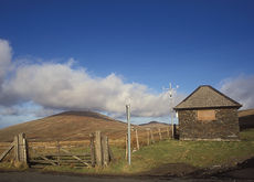 Brandywell TT Race Marshal Shelter and Weather Station on the A18 Mountain Road/B10 Sartfield Road looking north towards Snaefell Mountain and North Barrule
For the 1920 Isle of Man TT Races, changes were made to the Mountain Course and competitors now turned left at Cronk-ny-Mona and followed the primary A18 Mountain Road to Governor's Bridge with a new start/finish line on Glencrutchery Road which lengthened the course from the pre-World War I length of 37,50 millas (60,35 km) to 37,75 millas (60,75 km). More changes to the course followed in 1923 with the adoption of a private road between Parliament Square and May Hill in Ramsey. The course had previously had negotiated the A2 Albert Road and Tower Road in Ramsey and the new course length was now 37,739 millas (60,74 km). The official course distance for the Snaefell Mountain Course was amended in 1938 to 37,733 millas (60,73 km) which is the current course length.[7]
For the 1934 Isle of Man TT Races major alterations to the Mountain Course were carried out which included the removal of the East Snaefell Mountain sheep-gate.[8] This was followed by the removal of the hump-backed bridge at Ballig and the road work was completed for the Manx Grand Prix in September 1935. Road widening occurred on the Mountain Course at the Highlander, Laurel Bank, Glen Helen (between the Old Quarry and Brew's Restaurant) and at Brandywell with the removal of the Beinn-y-Phott sheep-gate for the 1935 Isle of Man TT Races.[9] Road Improvements occurred at the 26th Milestone, Greeba Bridge and on the Sulby Straight for the 1938 Isle of Man TT Races. Further road widening and landscaping occurred at the Water Works Corner and road widening between the Gooseneck and the 26th Milestone for the 1939 Isle of Man TT Races.[10] A memorial to Jimmie Guthrie was built in 1939 at the The Cutting at a cost of £1,500.[11]
Course Changes 1947-1999
Major road widening occurred on the Snaefell Mountain course at the 33rd Milestone, including the removal of fence posts at road level and the removal of a section of a grass bank before the start of the 1947 Isle of Man TT Races.[12] Changes to the Mountain Course occurred for the 1953 Isle of Man TT Races including road widening at Bedstead Corner, elevation works at Signpost Corner and Cronk-ny-Mona and the widening of the corner at Gorse Lea.[13] Before the commencement of racing for the 1953 Manx Grand Prix, the cottage at Appledene Corner was demolished between the 6th and 7th Milestone road-side marker on the primary A1 Douglas to Peel road on the Mountain Course.[14] Further changes occurred to the Mountain Course to facilitate racing on the Clypse Course and during the winter of 1953/54 road widening occurred on the primary A18 Mountain Road at Creg-ny-Baa, Signpost Corner, Cronk-ny-Mona and at the approach to Governor's Bridge.[15] The approach to the Quarterbridge on the primary A2 Douglas to Peel road was widened and re-profiled and the jumps at the Highlander and adjacent to Ballagarraghyn Cottages were removed for the 1954 Isle of Man TT Races.[16] Other major course alterations for the 1954 Isle of Man TT Races included road widening at Appledene, Handley's Corner, Barregarrow, Rhencullen, Ballaugh Bridge, Ginger Hall (Sulby) and Kerrowmoar.[17] During the winter of 1957/58 the hotel at the Bungalow tram-crossing was removed on the Mountain Section of the course.[18] [19]
During the 1960s further road-widening occurred at Ballig and also at Greeba Bridge on the primary A1 Douglas to Peel road. In 1963 a roundabout was added to the road junction at the Quarterbridge.[20] The winter of 1970/1971 road-widening occurred on the A18 Mountain Road at Verandah by cutting into the hillside.[21] The winter of 1975/76 road-widening and landscaping occurred at Snugbrough on the primary A2 road at the 2nd Milestone.[22] The winter of 1986 further re-profiling occurred at the Quarterbridge road junction with a new road traffic system including two new mini-roundabouts, the removal of a traffic island and trees. Road re-profiling and widening occurred at Quarry Bends during the winter of 1987. During the winter months of 1991/1992 the A18 Mountain Road was closed for repair work to the road foundation between the 26th Milestone and the Mountain Box and also between the Windy Corner and Keppel Gate.[23]
Course Changes from 2000
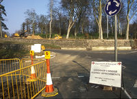 Governor's Bridge road junction between the A18 Bemahauge Road and the A2 Governor's Road.
From 2003 to 2006, road repair work was carried-out on the primary A3 road from Barregarrow to Cronk-y-Voddy, including Handley's Corner and the 11th Milestone. In 2004 the western-side embankment was removed from Guthrie's Memorial on the A18 Mountain Road. Also, during the winter of 2004/2005 road widening occurred at Windy Corner followed by Brandish Corner during the winter of 2005/2006 by the Isle of Man Department of Transport. In October 2007 the Isle of Man Department of Transport began road widening at Braddan Bridge on the Mountain Course with the creation of a new roundabout incorporating the 'Jubilee Oak' Tree on the A1 Douglas to Peel Road. The Department of Transport also announced the proposal of building a new section of road and roundabout for the Mountain Course with a link road from Signpost Corner to Governor's Bridge using the existing A18 Bemahague Road. This road widening scheme began in February 2008[24] with the removal of trees on the Bemahague Estate which included Government House, the official residence of the Lieutenant Governor of the Isle of Man and the creation of a small mini-roundabout. Further work by the Isle of Man Department of Transport in July and September 2008 included the installation of a storm drain and the completion of the mini-roundabout. The Isle of Man TT Races and Manx Grand Prix continued to use the original A18 Bemahauge Road that runs parallel to the new link road and the Governor's Dip for motor-cycle racing. In July 2008, the Isle of Man Department of Transport announced a £4 Million road safety scheme for the Quarterbridge road junction, including the building of a new roundabout and the demolition of the Quarterbridge Hotel.[25] In August 2009, for the 2009 Manx Grand Prix a section of grass bank is removed from the southern side of Keppel Gate. This is to provided a run-off area after the crash in evening practice by the Australian competitor Cameron Donald and a further incident involving a TT Travelling Marshall at Keppel Gate during the 2009 Isle of Man TT Races. Further road repair work is carried out by the Highways Division, Isle of Man Department of Infrastructure and the Isle of Man Water Authority between Cronk Urleigh and the 13th Milestone during the winter of 2010. The Highways Division modify the road junction at Signpost Corner including improved drainage, elevation changes and repairs to the road surface in November 2010.
Official lap records
The official lap record for the Snaefell Mountain Course is 17 Minutes and 12.30 seconds at an average speed of 131,578 mph (211,754264832 km/h) set by John McGuinness during the 2009 Senior TT Race. The race record is held by Steve Plater in 1 hour, 45 minutes and 53.15 seconds; an average race speed of 128.278 mph during the same 6 lap (236.38 Miles) 2009 Senior TT race.[26]
The lap record for the Sidecar TT is 19 minutes and 24.24 seconds at an average speed of 116.667 mph set by Nick Crowe and passenger Daniel Sayle during the 2007 Sidecar Race B.[27] The race record for the Sidecar TT is 58 minutes and 59.28 seconds at an average race speed of 115.132 mph for 3 laps (113.00 miles) of the course, held by Dave Molyneux and Daniel Sayle during the 2009 Sidecar Race A.[28]
In the 2006 TT practices New Zealander Bruce Anstey achieved the unofficial current top speed record of 206 mph (331,524864 km/h).[29] at the end of Sulby straight on a Suzuki 1000cc machine. This speed value was registered by the on-board datalogging equipment and can not be considered as an official record.
Ciclismo
El mismo trazado ha sido utilizado para carreras de ciclismo, incluyendo contrarrelojes y, desde 1936, la carrera en masa Manx International. La primera carrera fue el día 18 de junio de 1936, y fue ganada por Charles Holland, del Midland Cycle and Athletics Club, en una hora, 42 minutos y 57 segundos, el tiempo que tardó en completar una vuelta al trazado.[30]
Curvas con nombre
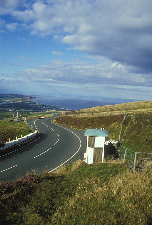
 Caseta de comisarios del TT en la carretera A18, hacia el norte está Guthrie's Memorial y el Point of Ayre.
Se estima que hay más de 200 curvas en este circuito, y alrededor de 60 de ellas tienen nombres. La primera curva que fue bautizada con el nombre de un competidor fue Edges Corner, en 1920, sita en la carretera A21, llamada Johnny Watterson's Lane en la zona más montañosa, entre Cronk-ny-Mona y la carretera A22, apodada Ballanard Road en Douglas, usada para la competición entre 1911 y 1922.[31] Parte de esta zona montañosa fue llamada Brandish Corner después de que Walter Brandish tuviera un accidente en el arrollo situado a la derecha del trazado, mientras intentaba adelantar a otro competidor en Upper-Hillberry Corner (anteriormente conocida como Telegraph Hill) entre Creg-ny-Baa y Hillberry Corner, y se rompió una pierna durante las prácticas para la edición 1923 del TT Isla de Man.[32] Durantes las primeras prácticas matutinas de la edición de 1927 de la misma carrera, Archie Birkin giró bruscamente para evitar chocar contra una furgón frigorífico de pescado que viajaba hacia Peel y colisionó contra un muro que le llevó a la muerte. La curva en Kirk Michael sita en la carretera A3, dónde ocurrió el accidente fue renombrada como Birkin's Bend. Desde 1928 las sesiones de prácticas de las carreras que se celebran en este trazado se disputan en carreteras cerradas al tráfico. La Ballameanagh Corner entre el 11th Milestone y el 12th Milestone fue renombrado como Handley's Corner después de que Wal Handley, que montaba una motocicleta Rudge sufriera un accidente en la primera vuelta de la edición de 1932 del Tourist Trophy, que le provocó daños en la espalda y por consiguiente se retiró de la carrera. Desde 1939 hay un monumento de piedra a Jimmie Guthrie, en The Cutting, sito en la A18, por lo que la curva en S fue renombrada como Guthrie's Memorial.[33]
Una colisión durante la práctica vespertina de la edición de 1952 del Tourist Trophy, en la que Bill Doran se estrelló entre el punte de Ballig y Laurel Bank, provocó que en la curva ubicada en el lugar descrito fuera renombrada como Doran's Bend. Un cobertizo de piedra con estilo de cabaña alpina fue construida en 1955 en memoria de Les Graham, el primer campeón mundial de 500 cc, en la carretera montañosa A18[34] La curva se llama Les Graham Memorial, también conocida como Bungalow Bridge. La sección en cuesta ascendente del Mountain Course desde Bungalow hasta la cota más alta de la pista, cerca de Brandywell, fue rebautizada como Hailwood Rise en memorai de Mike Hailwood, antiguo campeón del Mundo de motocicletas en 1981, y el punto más elevado del trazado es Hailwood Height's, adyacente al cruce con la carretera de Brandywell.[35] En 2003 el 32nd Milestone fue renombrado 'Dukes'[36] debido al campeón de motocicletas de los años 1950 Geoff Duke y el 26th Milestone también cambió su nombre por el de Joey's, por el campeón del TT Fórmula 1 Joey Dunlop. En contraste, el nombre de 'Ago's Leap' es un tanto poco apropado para la sección entre el cruce de Brunswick Road/Selborne Drive y Quarterbridge Road con Bray Hill/Cronkbourne Road en Douglas, que es un nombre extraoficial usado en los medio de comunicación en general.
Véase también
- TT Isla de Man
- Manx Grand Prix
- Clypse Course
- St. John's Short Course
- List of Snaefell Mountain Course fatal accidents
Referencias
- ↑ Isle of Man Centenary TT - ACU/MMCC Official Race Guide pp67 Isle of Man Department of Tourism and Leisure (2007) Mannin Media Group Ltd
- ↑ Official TT Guide 1992 pp 45 Mannin Media Publication/Isle of Man Department of Tourism
- ↑ Island Racer 2004 pp 112-113 Mortons Media Group Ltd ISSN 1743-5838
- ↑ The Statutes of the Isle of Man Vol VII from 1896 to 1905 pp569 Edited by C.T.W Hughes-Games Brown and Sons Ltd
- ↑ TT Pioneers - Early Car Racing in the Isle of Man pp 103-104 Robert Kelly, Mercury Asset Management (1996)(1st Edition) The Manx Experience, The Alden Press ISBN No 1 873120 61 3
- ↑ TT Pioneers - Early Car Racing in the Isle of Man pp 103-104 Robert Kelly, Mercury Asset Management (1996)(1st Edition) The Manx Experience, The Alden Press ISBN No 1 873120 61 3
- ↑ Official TT Guide 1992 pp 45 edited by Norrie White Isle of Man Department of Tourism (1992) Mannin Media Ltd
- ↑ Isle of Man Examiner dated 31st May 1934
- ↑ Isle of Man Weekly Times dated 25th May 1935
- ↑ Isle of Man Weekly Times pp4 dated 13th May 1939
- ↑ Isle of Man Weekly Times pp18 dated 17th June 1939
- ↑ Isle of Man Weekly Times dated 12th May 1947
- ↑ Isle of Man Weekly Times pp7 dated 25th April 1953
- ↑ Isle of Man Examiner pp12 dated 14th August 1953
- ↑ Isle of Man Examiner pp12 dated 5th January 1954
- ↑ TT 100 - The Authorised History of the Isle of Man Tourist Trophy Racing by Mick Duckworth pp111 (2007)(1st Edition) Lily Publications ISBN 1-8996067-4
- ↑ Isle of Man Examiner pp6 dated 28th May 1954
- ↑ Isle of Man Examiner pp1 dated 10 April 1958
- ↑ TT 100 - The Authorised History of the Isle of Man Tourist Trophy Racing by Mick Duckworth pp29 (2007)(1st Edition) Lily Publications ISBN 1-89960-67-4
- ↑ Isle of Man Examiner pp5 dated 6th June 1963
- ↑ Isle of Man Weekly Times pp1 dated 6th January 1971
- ↑ TT 100 The Official Authorised History of Isle of Man Tourist Tophy Racing page 21 by Mick Duckworth Editor Miles Coswell (2007)(1st Edition) Lily Publications Ltd ISBN 1 899602 67 4
- ↑ Official Isle of Man TT Programme 1992 pp 45 edited by Norrie White Isle of Man Department of Tourism (1992) Mannin Media Ltd
- ↑ Isle of Man Examiner pp5 dated 5th February 2008
- ↑ Manx Independent pp3 dated 4th July 2008
- ↑ Isle of Man Examiner page 18 dated 16 June 2009 Isle of Man Newspapers ISSN 1358-4383
- ↑ TT Centenary News - Issue 3 pp11 dated 6th June 2007 - Isle of Man Newspapers Ltd ISSN 1471-7905
- ↑ Bike Sport News - TT 2009 Special Issue 238 page 7 dated 16th June 2009 BSN Ltd
- ↑ http://www.motorcycledaily.com/20june06_ttspeed.htm New Isle of Man Top Speed Record (retrieved 12 August 2006)
- ↑ Isle of Man Examiner pp15 dated 29 January 2008
- ↑ TT 100 - The Authorised History of the Isle of Man Tourist Trophy Racing by Mick Duckworth pp29 (2007)(1st Edition) Lily Publications ISBN 1-89960-67-4
- ↑ Isle of Man Weekly Times pp3 dated 9th June 1923
- ↑ Isle of Man Weekly Times pp18 dated 17th June 1939
- ↑ Isle of Man Examiner pp9 dated 10th June 1955
- ↑ Isle of Man TT Festival Fortnight 1-12 June 1981 - Official Souvenir Programme page 17 Isle of Man Tourist Board The Auto-Cycle Union (1981) J.M. Noble Ltd, Isle of Man
- ↑ TT News - Issue 1 pp20 dated 1st June 2003
Enlaces externos
 Wikimedia Commons alberga contenido multimedia sobre Snaefell Mountain CourseCommons.
- Circuit Guide with Steve Hislop, 11 times TT winner
- 2D and 3D Maps of the TT Course
Coordenadas:Categorías:- Campeonato Mundial de Motociclismo de Velocidad
- Deporte en la Isla de Man


Wikimedia foundation. 2010.