Tahuya, Washington — Tahuya is an unincorporated community in Mason County, Washington, United States. It is located on the Hood Canal. Tahuya features a number of recreational areas.The first Saturday in July marks the annual Tahuya Day celebration, which includes a … Wikipedia
Washington Natural Areas Program — The Washington Natural Areas Program, part of the Washington Department of Natural Resources, manages dozens of natural areas owned by the US state of Washington. These areas have received funding through the state s general fund since the… … Wikipedia
Scouting in Washington — has a long history, from the 1910s to the present day, serving thousands of youth in programs that suit the environment in which they live. Contents 1 Early history (1910–1950) 2 Recent history (1950–present) 3 Scouting in Washington today … Wikipedia
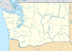
Mason County, Washington — Location in the state of Washington … Wikipedia
Belfair, Washington — Belfair is an unincorporated community in Mason County, Washington, United States. Located at the head of the Hood Canal, a branch of Puget Sound, it serves as the commercial center of North Mason. The population of the surrounding area swells in … Wikipedia
List of unincorporated communities in Washington — This is a list of unincorporated communities in the U.S. state of Washington which are not incorporated municipalities. Incorporated municipalities in the state are listed separately in a list of cities and list of towns. Contents 1 Census… … Wikipedia
Condado de Mason (Washington) — Para otros usos de este término, véase Condado de Mason. Condado de Mason Condado de los Estados Unidos … Wikipedia Español
Clark Island (Washington) — Clark Island is an island in the San Juan Islands of the U.S. state of Washington. It is located near Barnes Island off the northeast coast of Orcas Island. Clark Island Marine State Park encompasses the entire 55 acre (22 ha) island, seven… … Wikipedia
Manchester State Park (Washington) — Manchester State Park is a 111 acre (45 ha) state park with 3,400 feet (1,000 m) of shoreline, located on Washington s Kitsap Peninsula. It was at one time a harbor defense installation for the protection of nearby Bremerton, then a… … Wikipedia
Crawford State Park (Washington) — Crawford State Park is located near the Canadian border in Pend Oreille County, Washington. It contains Gardner Cave, which is over 1,055 feet (322 m) feet in length and has stalactites and stalagmites. It is the third longest natural… … Wikipedia
 Tahuya
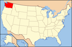
 Estados Unidos
 Washington
 Portal:Washington. Contenido relacionado con Washington.
 Wikimedia Commons alberga contenido multimedia sobre Tahuya (Washington). Commons
