- Toutle (Washington)
-
Toutle Área no incorporada de los Estados Unidos Ubicación en el condado de Cowlitz en el estado de Washington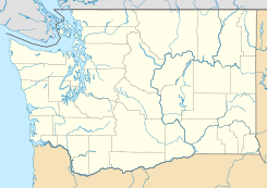
 Toutle
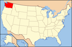
Ubicación de Washington en EE. UU.Coordenadas: Entidad Área no incorporada • País  Estados Unidos
• Estado  Washington
• Condado Cowlitz Altitud • Media 97 msnm Huso horario Pacífico: UTC-8 • en verano UTC-7 Código ZIP 98.649 Código de área 360 Toutle es un área no incorporada ubicada en el condado de Cowlitz en el estado estadounidense de Washington.
Geografía
Toutle se encuentra ubicado en las coordenadas Coordenadas: .[1]
Referencias
- ↑ «American FactFinder» (en inglés). Oficina del Censo de los Estados Unidos. Consultado el 11 de julio de 2011.
Enlaces externos
 Portal:Washington. Contenido relacionado con Washington.
 Wikimedia Commons alberga contenido multimedia sobre Toutle (Washington). Commons
Categorías:- Áreas no incorporadas de Washington
- Localidades de Washington
- Localidades del condado de Cowlitz (Washington)


Wikimedia foundation. 2010.