Yagishiri

Yagishiri
Isla Yagishiri
焼 尻 岛 Yagishiri-tō
Hokkaido Yagishiri Isle.jpg
Localización
País Bandera de Japón Japón
Prefectura Flag of Hokkaido Prefecture.svg Hokkaidō
Mar Mar del Japón
Coordenadas 44°26′N 141°24′E / 44.433, 141.4Coordenadas: 44°26′N 141°24′E / 44.433, 141.4
Geografía
Superficie 5,21 km²
Punto más alto 94 m
Demografía
Población 379
Densidad 72,74 hab./km²

La Isla Yagishiri[1] (en japonés: 焼 尻 岛 Yagishiri-tō) es una pequeña isla en el mar del Japón, a 25 km al oeste de Haboro. Es parte de la Subprefectura de Rumoi en Hokkaido, al norte de Japón. Junto con isla Teuri, que esta hacia el oeste a través del estrecho de Musashino, es administrada por la ciudad de Haboro. La superficie de la isla es de 5,21 km² y está habitado por 379 personas (según datos de 2003).

La isla es notable por la belleza de su naturaleza. Gran parte de la superficie de las islas está cubierta de bosques vírgenes, especialmente de Taxus cuspidata, una especie de tejo japonés. Por estas razones, se declarar una parte como el Parque Nacional Shokanbetsu-Teuri-Yagishiri (暑 寒 别 天 売 焼 尻 国 定 公园 Shokanbetsu Teuri Yagishiri Kokuritsu Koen).

Véase también

Referencias


Wikimedia foundation. 2010.

Игры ⚽ Нужно сделать НИР?

Mira otros diccionarios:

  • Yagishiri Island — Infobox Islands name = Yagishiri image caption = image size = locator map custom = no native name = native name link = nickname = 焼尻島, Yagishiri tō location = East Asia coordinates = coord|44|26|N|141|24|E|display=inline,title archipelago =… …   Wikipedia

  • Île Yagishiri — 焼尻島 (ja) Vue de l île Yagishiri. Géographie Pays …   Wikipédia en Français

  • Haboro (Hokkaidō) — Haboro chō 羽幌町 …   Deutsch Wikipedia

  • Teuri Island — Infobox Islands name = Teuri image caption = image size = locator map custom = no native name = 天売島, Teuri tō native name link = Japanese language nickname = location = East Asia coordinates = coord|44|25|N|141|18|E|display=inline,title… …   Wikipedia

  • Tomamae (Hokkaidō) — Tomamae chō 苫前町 …   Deutsch Wikipedia

  • Mashike Mountains — (増毛山地 Mashike Sanchi) Range …   Wikipedia

  • Teuri — Isla Teuri 天 売 岛 Teuri tō 
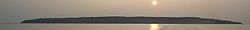
Localización País  Japón Prefectura …   Wikipedia Español

  • List of islands of Japan — The four main islands of Japan are:*Hokkaidō *Honshū *Kyūshū *ShikokuOkinawa is the fifth largest island except the disputed northern territories, and is the smallest island which has a prefectural capital. List of smaller islands of Japan… …   Wikipedia

  • List of national parks of Japan — in Japan are designated reserves of land, declared by the Ministry of the Environment under its National Parks Law. OverviewThe first national park was opened in 1939 while the Natural Parks Law, which regulates national, quasi national and other …   Wikipedia

  • Daisetsuzan National Park — This article is about Daisetsuzan National Park. For the volcanic group, see Daisetsuzan Volcanic Group. Daisetsuzan National Park 大雪山国立公園 IUCN Category II (National Park) …   Wikipedia

Compartir el artículo y extractos

Link directo
Do a right-click on the link above
and select “Copy Link”