Garvellachs

Garvellachs
Islas Garvellachs
(Garbh Eileaich)
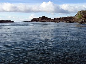
Garvellachs (RLH).JPG
Vista de las Garvellachs
Localización geográfica / administrativa
Océano (mar) Firth of Lorn (mar de las Hébridas)
Continente (sub) Europa
Grupo Hébridas Interiores (islas Británicas)
Ecorregión
País (es) Bandera del Reino Unido Reino Unido
División (es) Bandera de Escocia Escocia
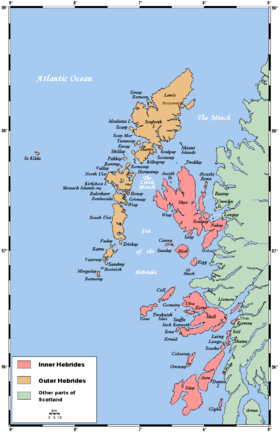
Subdivisión (es) Council Area de Argyll y Bute
Datos demográficos / geográficos
Población Deshabitadas
Capital administrativa
N.º de islas 3 y varios islotes
Islas
Garbh Eileach 1,42 km²
Eileach an Naoimh 0,56 km²
Dùn Channuill - km²

Punto más alto 110 m (en Garbh Eileach)
Accidentes del archipiélago

Coordenadas 56°14′N 5°47′O / 56.233, -5.783Coordenadas: 56°14′N 5°47′O / 56.233, -5.783
Mapas de localización
Red pog.svg
Localización aproximada de las Garvellachs (no aparecen) en las Hébridas Interiores (en rojo).
Red pog.svg
Localización de las Garvellachs

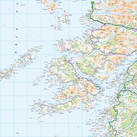
Las islas Garvellachs (gaélico escocés, Garbh Eileaich) o islas del Mar son un grupo de tres pequeñas islas de las Hébridas Interiores localizadas en la entrada del Firth of Lorn (mar de las Hébridas). Administrativamente, son parte del Area Council de Argyll y Bute (Escocia) y han estado deshabitadas desde la Segunda Guerra Mundial. Están situadas al oeste de la isla de Lunga y al noroeste de la de Scarba.

El grupo incluye las islas de Garbh Eileach, Dùn Channuill y Eileach an Naoimh y varios islotes menores.


Wikimedia foundation. 2010.

Игры ⚽ Поможем написать курсовую

Mira otros diccionarios:

  • Garvellachs — Garbh Eileaich (gd) Les Garvellachs (dernier plan) vues depuis Cullipool (premier plan) …   Wikipédia en Français

  • Garvellachs — The Garvellachs (Scottish Gaelic: Garbh Eileaich) or Isles of the Sea form a small archipelago in the Inner Hebrides of Scotland. Part of the Argyll and Bute council area, they lie west of Lunga and northwest of Scarba and have been uninhabited… …   Wikipedia

  • Craobh Haven — is a small purpose built village and sailing port on the west coast of Argyll and Bute, Scotland. It is situated on the Craignish peninsula, one mile to the west of the A816, and approximately 22 miles (35 km) south of Oban. Craobh Haven is… …   Wikipedia

  • Hinba — ( gd. isles of the sea ) is an island in Scotland of unknown location that was the site of a small monastery associated with the Columban church on Iona. Although a number of details are known about the monastery and its early abbots, and various …   Wikipedia

  • Список островов Шотландии — Карта Внешних и Внутренних Гебрид Этот список содержит перечисление морских и пресноводных островов Шотландии (континентальная часть которой является частью острова Великобритания). Помимо того, в список включены связанные с рас …   Википедия

  • Scarba — Location …   Wikipedia

  • Garbh Eileach — Infobox Scottish island | latitude=56.24 longitude= 5.77 GridReference=NM665115 celtic name=Garbh Eileach norse name= meaning of name=rough rocky mound area=142 ha area rank= 128= highest elevation= 110 m Population=0 population rank= main… …   Wikipedia

  • Lunga, Firth of Lorn — Infobox Scottish island latitude=56.22 longitude= 5.70 GridReference=NM706086 celtic name=Lunga norse name=Langr oy meaning of name= Old Norse for isle of the longships area=254 ha (628 acres) area rank=96 highest elevation= Bidean na h Iolaire… …   Wikipedia

  • Dùn Channuill — Location …   Wikipedia

  • Eileach an Naoimh — Vorlage:Infobox Insel/Wartung/Fläche fehltVorlage:Infobox Insel/Wartung/Höhe fehlt Eileach an Naoimh Mönchszelle und …   Deutsch Wikipedia

Compartir el artículo y extractos

Link directo
Do a right-click on the link above
and select “Copy Link”