- Kamp-Lintfort
-
Armas Mapa 
Datos básicos Bundesland: Renania del Norte-Westfalia Distrito: Wesel Superficie: 63,16 km² Altura: 33 m Habitantes: 39.177 (31 de diciembre de 2007) Densidad poblacional: 620 Habitantes por km² Código postal: 47475 Prefijo telefónico: 0 28 42 Código administrativo: 05 1 70 020 Matrícula: WES Dirección de
la administración:Am Rathaus 2
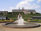
47475 Kamp-LintfortWebsite: www.kamp-lintfort.de La ciudad de Kamp-Lintfort pertenece al distrito de Wesel en el estado federal de Nordrhein-Westfalen (Alemania). La ciudad se ubica en la parte norte del Niederrhein y forma parte del Ruhrgebiet. Kamp-Lintfort es una ciudad de gran industria minera. Además en ella se ubica el monasterio Kamp perteneciente a la orden cisterciense.
Geografía
Kamp-Lintfort está en la tierra baja del Niederrhein. Está al lado de Duisburg
El barrios son:
- Lintfort
- Kamp
- Eyll
- Geisbruch
- Gestfeld
- Hoerstgen
- Kamperbruch
- Kamperbrück
- Rossenray
- Saalhoff
Ciudades hermanadas
Categorías:- Localidades de Renania del Norte-Westfalia
- Cuenca del Ruhr


Wikimedia foundation. 2010.