Llangristiolus

Llangristiolus
Llangristiolus
Localidad de Gales
Localización de Llangristiolus en Gales
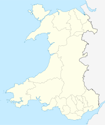
Ubicación dentro de Gales
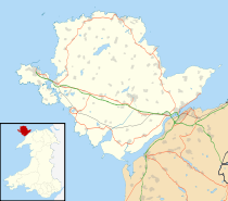
Localización de Llangristiolus en Anglesey
Ubicación dentro de Anglesey
Entidad Localidad
 • País Bandera de Gales Gales
 • Estado soberano Bandera del Reino Unido Reino Unido
 • Área principal Anglesey
 • Condado ceremonial Gwynedd
Parlamento Europeo
Parlamento del Reino Unido
Ynys Môn
Ynys Môn
Código postal LL62
Prefijo telefónico 01248
Código de ciudad BODORGAN
Policía North Wales
Bomberos North Wales
Ambulancia Welsh

Llangristiolus es un pueblo en el centro de Anglesey, al suroeste de Llangefni, y debe su nombre a san Cristiolus. El río Cefni discurre por el pueblo. Esta población se sitúa a una milla de las carreteras A5 y A55.

Fue el hogar de Meinir Gwilym, que nació en Gales en 1983, y se educó en Ysgol Henblas, en Llangristiolus.

Enlaces externos


Wikimedia foundation. 2010.

Игры ⚽ Поможем написать курсовую

Mira otros diccionarios:

  • Llangristiolus — infobox UK place latitude = 53.235 longitude = 4.345 country = Wales welsh name= constituency welsh assembly= Ynys Môn population= official name= Llangristiolus unitary wales= Anglesey lieutenancy wales= Gwynedd constituency westminster = Ynys… …   Wikipedia

  • Isle of Anglesey County Council — The Isle of Anglesey County Council (Welsh: Cyngor Sir Ynys Môn) is the governing body for the county of Anglesey, one of the unitary authority areas of Wales. The council consists of 40 councillors, representing 40 electoral wards. Contents 1… …   Wikipedia

  • Meinir Gwilym — Born 1983 Origin Llangristiolus, Wales, United Kingdom Genres Folk, Pop Occupations Singer …   Wikipedia

  • Anglesey — For other places with the same name, see Anglesey (disambiguation). Isle of Anglesey Ynys Môn Geography Area Total  % Water …   Wikipedia

  • Кристиол — Южная сторона храма св. Кристиола, с нефом слева и алтарём справа …   Википедия

  • Newborough, Anglesey — Coordinates: 53°09′53″N 4°21′32″W / 53.16479°N 4.35900°W / 53.16479; 4.35900 …   Wikipedia

  • Menai Bridge — For the bridges across the Menai Strait, see Menai Suspension Bridge and Britannia Bridge. Coordinates: 53°14′N 4°10′W / 53.23°N 4.16°W …   Wikipedia

  • List of communities in Wales — This is a list of communities in Wales sorted by principal area. The community is the lowest tier of local government in Wales and is usually represented by a community council. Contents 1 Blaenau Gwent 2 Bridgend 3 Caerphilly …   Wikipedia

  • List of places in Anglesey — This is a list of cities, towns and villages in the principal area of Anglesey, Wales. See the list of places in Wales for places in other principal areas.compactTOC NOTOC A*Aberffraw *Amlwch *Amlwch PortB*Beaumaris *Belan *Benllech *Bodedern… …   Wikipedia

  • Din Lligwy — House foundations at Din Lligwy hut circle, Anglesey, August 2, 2004 Din Lligwy (or Din Llugwy) hut circle is an ancient village site near the east coast of Anglesey, close to the village of Moelfre, North Wales. Excavations in 1905 1907 produced …   Wikipedia

Compartir el artículo y extractos

Link directo
Do a right-click on the link above
and select “Copy Link”