Mayreau

Mayreau

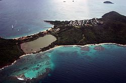
Mayreau, es una isla ubicada en el sureste del mar Caribe, que geográficamente pertenece al Archipiélago de las Granadinas y políticamente es parte del país de San Vicente y las Granadinas.

Es una isla pequeña de aproximadamente 1,5 millas cuadradas, con una población que apenas alcanza las 300 personas, concentrada básicamente en la localidad de Old Wall en la parte alta del suroeste de la isla. Es una Comunidad aislada ya que sólo se puede acceder a ésta por vía marítima a través de botes, ante la falta de un aeropuerto.

El servicio de electricidad es algo reciente siendo apenas instalado a partir del año 2002, provista por un generador central. Las principales actividades económicas son el turismo y la pesca.

Véase también

Enlaces externos

Coordenadas: 12°39′N 61°23′O / 12.65, -61.383


Wikimedia foundation. 2010.

Игры ⚽ Нужно сделать НИР?

Mira otros diccionarios:

  • Mayreau — Baie Saltine et le village Old Wall Géographie Pays …   Wikipédia en Français

  • Mayreau — Luftaufnahme der Insel Gewässer Karibisches Meer Inselgruppe …   Deutsch Wikipedia

  • Mayreau — Saline Bay and Old Wall village Mayreau is the smallest inhabited island of the Grenadines, with an area of about 1.5 sq. miles, and a population of about 300. The population is centered in Old Wall village, located on a hilltop in the southwest… …   Wikipedia

  • Mayreau — Sp Mairò nkt. Ap Mayreau L s. Grenadinuose, Sent Vinsentas ir Grenadinai …   Pasaulio vietovardžiai. Internetinė duomenų bazė

  • Tobago Cays — are an archipelago comprised of five small uninhabited islands Petit Rameau, Petit Bateau, Baradol, Petit Tobac and Jamesby located in the Southern Grenadines. The Tobago Cays are now the key element of the Tobago Cays Marine Park, a national… …   Wikipedia

  • Saint Vincent And The Grenadines — Introduction Saint Vincent and the Grenadines Background: Disputed between France and the United Kingdom in the 18th century, Saint Vincent was ceded to the latter in 1783. Autonomy was granted in 1969, and independence in 1979. Geography Saint… …   Universalium

  • Joseph Lambert Eustace — Mandats 2e Gouverneur général de Saint Vincent et les Grenadines 28 fév …   Wikipédia en Français

  • Geography of Saint Vincent and the Grenadines — Map of Saint Vincent and the Grenadines Saint Vincent and the Grenadines is an island state in the Windward Islands of the Lesser Antilles, an island arc of the Caribbean Sea in North America. The country consists of the main island of S …   Wikipedia

  • Grenadines — The Grenades are a Caribbean island chain of over 600 islands in the Windward Islands. They are divided between the island nations of Saint Vincent and the Grenadines and Grenada. Islands of the Grenades include: * Young Island (Grenadines) *… …   Wikipedia

  • Union Island — is the southernmost island of the Grenadines belonging to the state of St. Vincent and the Grenadines It is situated 90 kilometers southwest of Barbados and the islands of Carriacou and the mainland of Grenada can be seen to the south.Clifton and …   Wikipedia

Compartir el artículo y extractos

Link directo
Do a right-click on the link above
and select “Copy Link”